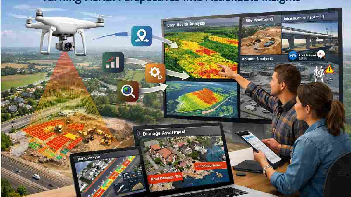
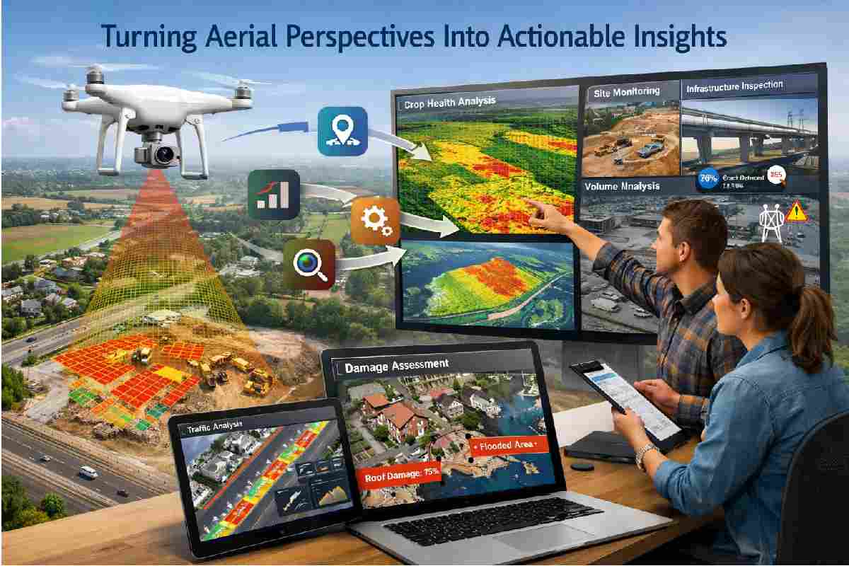
Turning Aerial Perspectives Into Actionable Insights – The ability to view the world from above has reshaped how individuals and organizations understand their surroundings. Aerial perspectives provide a broader context that ground-level observations often cannot capture, revealing patterns, connections, and opportunities that might otherwise remain hidden. As technology continues to evolve, these elevated viewpoints are becoming more accessible and increasingly valuable for transforming raw visual data into meaningful, actionable insights.
Table of Contents
The Expanding Role of Aerial Observation
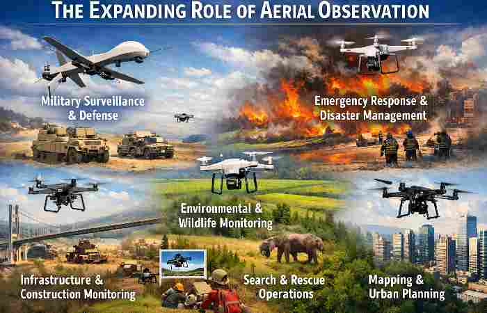
Historically, aerial observation was limited to specialized industries with access to aircraft or government-managed resources. Today, advancements in imaging technology and data processing have democratized access to this powerful perspective. Businesses, researchers, planners, and analysts can now examine landscapes, infrastructure, and environmental changes with remarkable clarity.
This shift has opened new avenues for decision-making. Instead of relying solely on reports or fragmented data sources, organizations can use aerial perspectives to validate assumptions and identify emerging trends. For example, visual assessments of urban growth can inform development strategies, while large-scale agricultural monitoring can help optimize crop management. The broader the viewpoint, the more comprehensive the understanding of how different elements interact within a given space.
From Visual Data to Strategic Planning
One of the most significant advantages of aerial insights lies in their ability to support long-term planning. Visual data can highlight changes over time, allowing organizations to anticipate challenges and respond proactively. Planners can track infrastructure expansion, monitor environmental shifts, and evaluate land use patterns to guide sustainable development initiatives.
By integrating tools such as Satellite images into their workflows, decision-makers gain access to up-to-date visual information that enhances strategic thinking. These images can reveal subtle variations in terrain, construction progress, or environmental conditions that may influence planning outcomes. The ability to interpret such data effectively can make the difference between reactive decision-making and forward-thinking strategy.
Enhancing Efficiency Across Industries
Aerial perspectives have proven to be particularly useful in industries where efficiency and accuracy are essential. In logistics and supply chain management, for instance, visual data can help optimize route planning and infrastructure placement. Similarly, in construction, aerial assessments allow teams to monitor project timelines, identify potential risks, and maintain alignment with design objectives.
Environmental monitoring also benefits greatly from aerial insights. Observing ecosystems from above enables researchers to assess deforestation, coastal erosion, or water resource distribution with greater precision. This information supports conservation initiatives and helps policymakers develop informed responses to environmental challenges.
The Importance of Contextual Analysis
While aerial imagery provides valuable information, its true impact emerges when combined with contextual analysis. Data interpretation requires an understanding of local conditions, industry requirements, and long-term objectives. Simply observing a landscape is not enough; insights must be derived through careful examination of patterns and relationships.
For instance, an aerial view of a rapidly developing area may suggest economic growth, but deeper analysis could reveal underlying infrastructure pressures or environmental risks. By pairing visual observations with data analytics and expert knowledge, organizations can transform raw images into meaningful guidance that supports confident decision-making.
Leveraging Technology for Real-Time Insights
Modern technology has significantly improved the speed at which aerial data can be collected and processed. Real-time access to visual information allows organizations to respond quickly to changing circumstances. Whether monitoring weather-related disruptions, tracking construction progress, or evaluating market expansion opportunities, timely aerial insights can enhance operational agility.
Cloud-based platforms and advanced visualization tools further amplify the value of aerial perspectives. Interactive mapping systems and integrated data dashboards enable users to explore visual information alongside other datasets, fostering a more holistic understanding of complex scenarios. This integration ensures that aerial insights are not isolated observations but part of a broader analytical framework.
Building a Future Guided by Elevated Perspectives
As the demand for data-driven decision-making continues to grow, aerial perspectives will play an increasingly central role in shaping strategies and outcomes. Organizations that embrace these elevated viewpoints can gain a competitive edge by identifying opportunities earlier, managing risks more effectively, and planning with greater confidence.
Ultimately, turning aerial perspectives into actionable insights requires more than access to visual data. It involves a commitment to thoughtful analysis, technological integration, and strategic application. By viewing challenges and opportunities from above, decision-makers can unlock new levels of clarity and transform observation into meaningful progress.